See Past the Fracking Hype
Globe and Mail
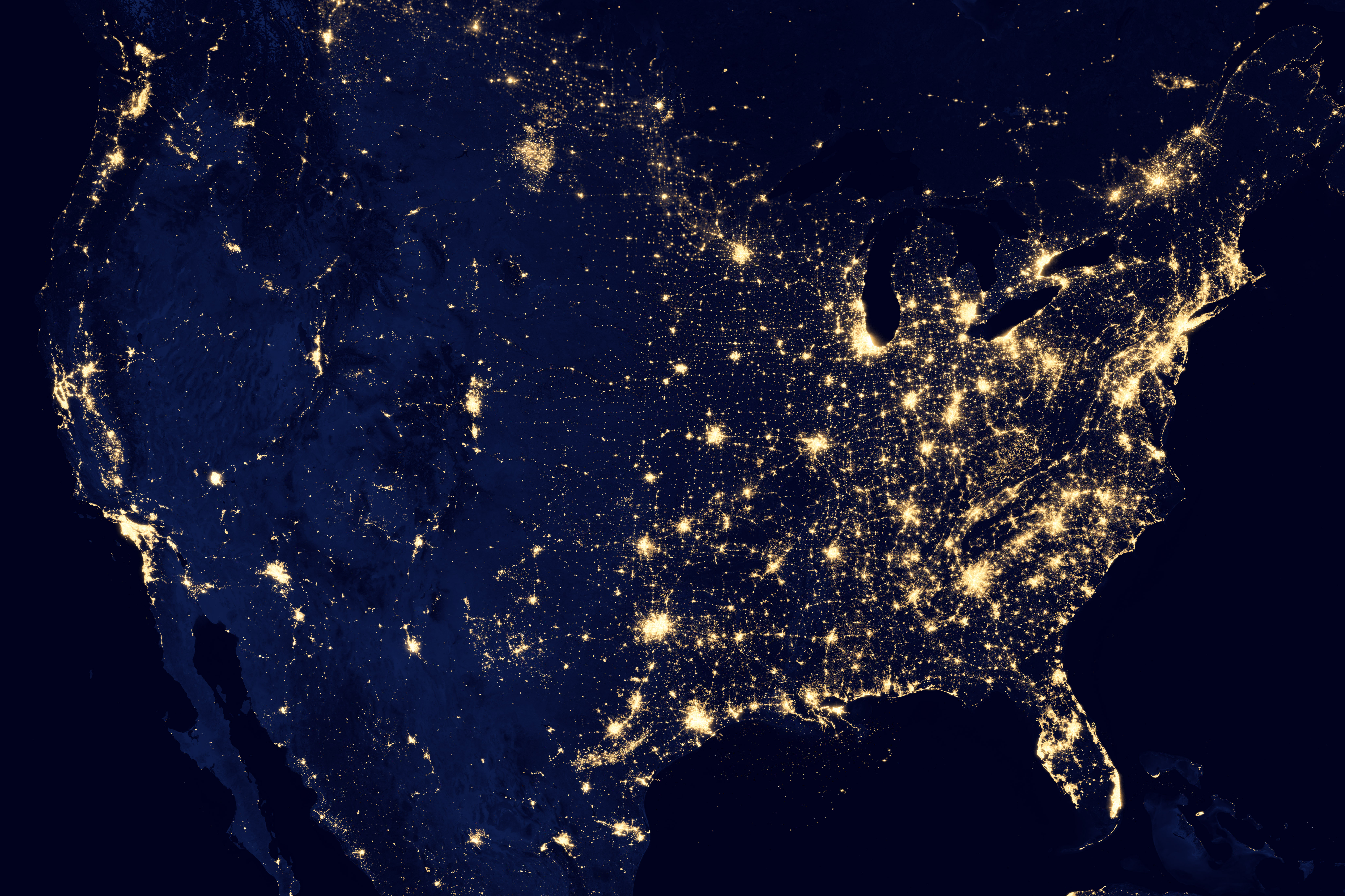
For years, NASA has produced a composite photograph of c. Taken by satellite, the photo shows huge patches of light marking New York, Los Angeles, and Toronto. Smaller patches mark cities like Denver, Seattle, and Calgary.
Recently something strange has appeared in this image. Another patch of light—larger than Chicago’s—now glows in a sparsely populated region just south of the Canada-US border near Saskatchewan.
The light comes from thousands of gas flares at oil wells tapping North Dakota’s Bakken shale. Farther south in Texas, a broad swath shaped like a scimitar marks the Eagle Ford shale play. In both places, drillers are mainly seeking oil. But because it’s often too costly to capture the natural gas associated with the oil, they burn it.
This flaring is a staggering waste of energy and a significant source of carbon emissions. But waste and environmental damage get short shrift in the popular discussion of these energy plays. Instead, the buzz is about how new hydrofracking technologies that liberate oil from shale have changed our energy future. The US is on course to be the world’s biggest oil producer and to achieve energy independence, the story goes. Shale plays around the planet mean we’ll soon be awash in oil, and prices will plummet.

But evidence is accumulating that fracking, at least when it comes to oil, has been hyped. Yes, the US is experiencing a short-term production boom, lasting perhaps another ten to fifteen years. Then its output will fall steeply. Globally, fracking isn’t going to change the fundamentals of the planet’s worsening oil-supply crunch. As the International Energy Agency says, fracking “does not mean that the world is on the cusp of a new era of oil abundance.”
No technology, no matter how ingenious, can repeal geology. It takes a huge amount of energy to drill long curving wells that follow horizontal strata kilometers from the well head, then crack the shale with high-pressure water and chemicals, and finally bring the liberated oil to the surface. Also, output from these wells drops quickly.
In a recent optimistic analysis, the US Energy Information Administration says drillers are learning how to put holes in the ground faster and release more oil from each hole; rig productivity in the Bakken field has quadrupled since 2007. But a close look at the data suggests that the EIA exaggerates the trend: rig productivity has actually varied wildly, and it may have been higher in 2009. Also, output from wells over a month old is declining 6.3 percent each month, for an annual rate of 53 percent.
A 53 percent annual decline is worse than analysts’ most pessimistic estimates. Canadian geologist David Hughes has examined Bakken drilling data closely and puts the figure at 44 percent. Either way, when it comes to shale oil, exploration companies face the ultimate Red Queen energy race: they have to run flat out just to stay in place. In an industry magazine, Lynn Westfall, EIA’s director of energy markets, acknowledges the problem. “For every 100 barrels you produce from new Bakken wells, 70 barrels of that go just to replace the decline from old wells.”
But the problems don’t end there. So much energy is needed to drill these wells that only the best produce a large energy surplus. Egan Waggoner, a graduate researcher working with Charles Hall at State University of New York, has done preliminary calculations. For wells in Bakken’s “sweet spot,” which makes up roughly a third of the field’s total area, the energy return is around 12 to 1—about the return of US conventional oil wells. For wells outside the sweet spot, the return is 4 to 1 or less. As a result, drillers generally tap the sweet spot first and move to less-productive zones later. Hughes estimates that Bakken’s output will peak before 2020 and that, if drilling continues at current rates of about 2,000 wells a year, the field will be saturated with wells by 2025.
The price of Brent crude, which is the international benchmark, has stayed between 100 to 125 dollars a barrel for the last three years despite a struggling world economy. An OECD analysis released earlier this year projects a price of 190 dollars by 2020, given reasonable estimates of oil demand in India and China. Fracking may change the oil supply balance in North America for a while, but it’s not going to change the underlying global reality: cheap oil is a thing of the past.
About the NASA Photo
This image of the United States of America at night is a composite assembled from data acquired by the Suomi NPP satellite in April and October 2012. The image was made possible by the new satellite’s “day-night band” of the Visible Infrared Imaging Radiometer Suite (VIIRS), which detects light in a range of wavelengths from green to near-infrared and uses filtering techniques to observe dim signals such as city lights, gas flares, auroras, wildfires, and reflected moonlight.
“Nighttime light is the most interesting data that I’ve had a chance to work with,” says Chris Elvidge, who leads the Earth Observation Group at NOAA’s National Geophysical Data Center. “I’m always amazed at what city light images show us about human activity.” His research group has been approached by scientists seeking to model the distribution of carbon dioxide emissions from fossil fuels and to monitor the activity of commercial fishing fleets. Biologists have examined how urban growth has fragmented animal habitat. Elvidge even learned once of a study of dictatorships in various parts of the world and how nighttime lights had a tendency to expand in the dictator’s hometown or province.
Named for satellite meteorology pioneer Verner Suomi, NPP flies over any given point on Earth’s surface twice each day at roughly 1:30 a.m. and p.m. The polar-orbiting satellite flies 824 kilometers (512 miles) above the surface, sending its data once per orbit to a ground station in Svalbard, Norway, and continuously to local direct broadcast users distributed around the world. Suomi NPP is managed by NASA with operational support from NOAA and its Joint Polar Satellite System, which manages the satellite’s ground system.

North America at night by NASA
Topics
Energy
Environmental Stress and Conflict
